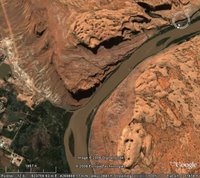
 People tend to look at Google Earth as just a neat way to look at satellite images of your house, school or the Golden Gate Bridge. Which it is. But folks don't realize that it a tool for creating and sharing geospatial content as well.
Perhaps the best example of this is the GPS upload feature (available in Google Earth Plus and Pro). This allows you to upload your tracks from your GPS device to Google Earth. You can then view a visual depiction of your mountain bike ride, favorite trail or hiking trip and share it with other Google Earth users. In fact, you can even show this information in Google Maps (example).
How do I know this stuff? I write user documentation for Google Earth, including this user guide. I consider the mission of my job to educate users all about the amazing stuff you can do in this software. Create and view 3D models, measure distances, view weather maps, add placemarks of cool locations, visit Burning Man, etc. And look at satellite images of your house.
Oh yeah, I almost forgot... you can view the 24 Hours of Moab course here :-) We will have more 24 race content here soon.


6 comments:
Hi Guys,
Great looking course. This is a great way to use Google Earth. Have a look here http://www.markduncombe.co.uk/twrch/twrch.kmz for another example of the cool mountain bike stuff you can do with Google Earth. Make sure you tick the tracks box in the places window.
Cheers
Mark
Thats neat!
Btw, you guys are on google offical blog. props!
Haha, your bios are hilarious. Good luck at the race!
go team google!
I am sure that this is a basic thing but how would I get a *.kmz file into my blog without having a separate website that I can make a link from? In other words, how do I get my *.kmz stored on my google blogger site the same way that it stores pictures?
Sorry... I should add that I love you blog and it looks like it was a great time. All the best.
T.
Post a Comment