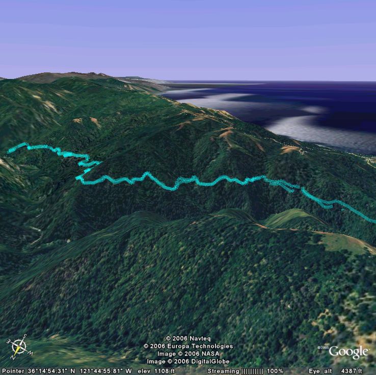
 I don't want to sound like I'm plugging Earth just because they're our sponsor for the race... I work on Gmail and I have actually had very little change to play around with Earth. But I was absolutely amazed when I loaded up our hike data. Whenever you're biking, hiking, boarding, or whatever, you're pretty much living in 2D. Sure there's rocks, descents, climbs, and the occasional huck but you don't really have a perspective your overall progress. The GPS device helps a bit -- it can show you your altitude profile, your moving average, and your tracks... but go home and load it up into Earth and you have a birds eye view of everything. I could barely contain my excitement as I rotated, zoomed, and panned our tracks, watching them snake along the edge of mountains, drop into valleys, and finally come to rest at our campsite 10 miles into Big Sur National Park.
I was hooked. If a 10 mile hiking trail was this cool, our epic rides must be killer. I immediately started bugging Dave to upload his GPS tracks into Earth so I could see what the trails we ride look like at a scale larger than that of the next switchback. But, what it came down to, is that I needed my own GPS.
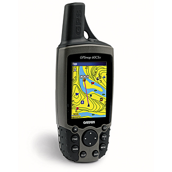 So, like the computer geek I am, I started doing online research. Dave has the Garmin Edge 305 which is made for biking. It's pretty sweet, tracks all the pertinent data like altitude, displace, average moving speed, etc., and even lets you race against yourself. The drawbacks are that there's no overall map and he occasionally loses signal deep into our ride as we sweep under thick forest canopies and down into valleys. After reading dozens of reviews, rants, and suggestions, besides the Edge, a lot of people recommended the Garmin eTrex Vista Cx which has the small size plus mapping capability but lacks the Edge's advanced SiRF chipset. I finally decided on the Garmin GPSMAP 60Csx. It has a nice big screen, mapping, the advanced SiRF chipset, and has gotten some great reviews by cyclists. The drawback over the edge is that it's a bit bulkier and with it's external antenna, you probably wouldn't want to mount it on your bars.
Garmin is offering a $50 rebate on most of their GPS devices, so now's a great time to get one. Plus, with a $20 upgrade to Google Earth Pro, you can import your data directly from any Garmin or Magellan GPS device. We'll have laptops running Earth at our booth, so swing by with your GPS device and we'll help you load up all your data so you can experience it for yourself.
I only wish I had a GPS years ago... there are so many places I've ridden that I may never see again.


1 comment:
視訊聊天室,視訊聊天室,視訊聊天室,視訊聊天室,視訊聊天室,視訊聊天室,視訊聊天室,視訊聊天室,視訊聊天室,視訊聊天室,視訊聊天室,視訊聊天室,視訊聊天室,視訊聊天室,視訊聊天室,視訊聊天室,視訊聊天室,視訊聊天室,視訊聊天室,視訊聊天室,視訊聊天室,視訊聊天室,視訊聊天室,視訊聊天室,視訊聊天室,視訊聊天室,視訊聊天室,視訊聊天室,視訊聊天室,視訊聊天室,視訊聊天室,視訊聊天室,視訊聊天室,視訊聊天室,視訊聊天室,視訊聊天室,視訊聊天室,視訊聊天室,視訊聊天室,視訊聊天室,視訊聊天室,視訊聊天室,視訊聊天室,視訊聊天室,視訊聊天室,視訊聊天室,視訊聊天室,視訊聊天室,視訊聊天室,視訊聊天室,視訊聊天室,視訊聊天室,視訊聊天室
Post a Comment